

Comment & Analysis: Phibsborough, in Dublin 7, has the reputation of being a traffic hotspot. It has a major junction between two roads called Doyle’s Corner, which thousands of private cars, buses and trucks go through every day. It is also a place where thousands of people live and work, including this author.
When so much traffic goes through an area, a harmful pollutant is released in high quantities: Nitrogen Dioxide, or NO2. The EU obliges member states to monitor and respect limits of that particular pollutant, with a limit of 40µg/m3 annual average. The World Health Organisation (WHO) considers there is no safe level of air pollution, but has put a limit of 10µg/m3.
To know how much NO2 is present in an area, you need to measure it. The Environmental Protection Agency (EPA) is responsible for the monitoring of NO2 and has installed stations everywhere in the country.
Under EU law, it is obliged to monitor air quality in the most impacted areas, ie areas with a lot of traffic, like beside the M50. Phibsborough is one of the most congested areas in the city, yet NO2 is not monitored there. The closest air monitoring stations, in Cabra and on Mountjoy Square, do not monitor NO2 either.
The EPA has just published its latest report on air quality. It mentions localised concerns, but states that the air quality in Ireland is ‘generally good’. But if NO2 is not recorded regularly in areas like Phibsborough, are we sure the averages given in their report reflect reality? Over the past few years, some measurements have been made, and what we have may well show a starker picture of the reality of air pollution in Dublin’s inner city.
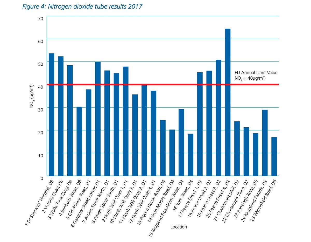
For example, in 2017, the EPA put diffusion tubes around central Dublin at 25 locations — these measurements showed breaches (of the EU levels) in the high-trafficked areas in the city such as Gardiner St or Pearse St. Every single one of the diffusion tubes showed levels breaching WHO’s levels.
Another set of data we have comes from the Clean Air Together campaign that the EPA ran with An Taisce. Diffusion tubes were placed on people’s buildings in October 2021. The results? 80% of Dublin air monitors exceed WHO limits for traffic-related pollution.
Rothar installed one of these tubes and results showed levels of NO2 of 34µg/m3. This is still EU-compliant, which is why no air quality plan has been drafted for an area like Phibsborough.
But when you dig a bit deeper, you can find figures from other sources. For example, we have access to figures for NO2 levels coming from the National Transport Authority and their BusConnects plan. The NTA is obliged to write an environmental report with each route, with a chapter dedicated to air quality. They used diffusion tubes such as the ones used for Clean Air Together, and modelled NO2 for each receptor.
We studied the data of the Ballymun/Finglas to City Centre and the Swords to City Centre schemes, which are going through Phibsborough, Glasnevin, Drumcondra and Dorset St. The Mater Private Hospital showed levels of 56µg/m3, and Temple St, where the Children’s Hospital is, shows levels of 48µg/m3.
Doyle’s Corner has levels around 52µg/m3. Church st fares the worst, with concentrations of 62µg/mm3, and most points in Drumcondra show levels of over 40µg/m3.
These are illegal levels of NO2. in the current legislation. When we asked the EPA about those, they were simply not aware of those measurements.
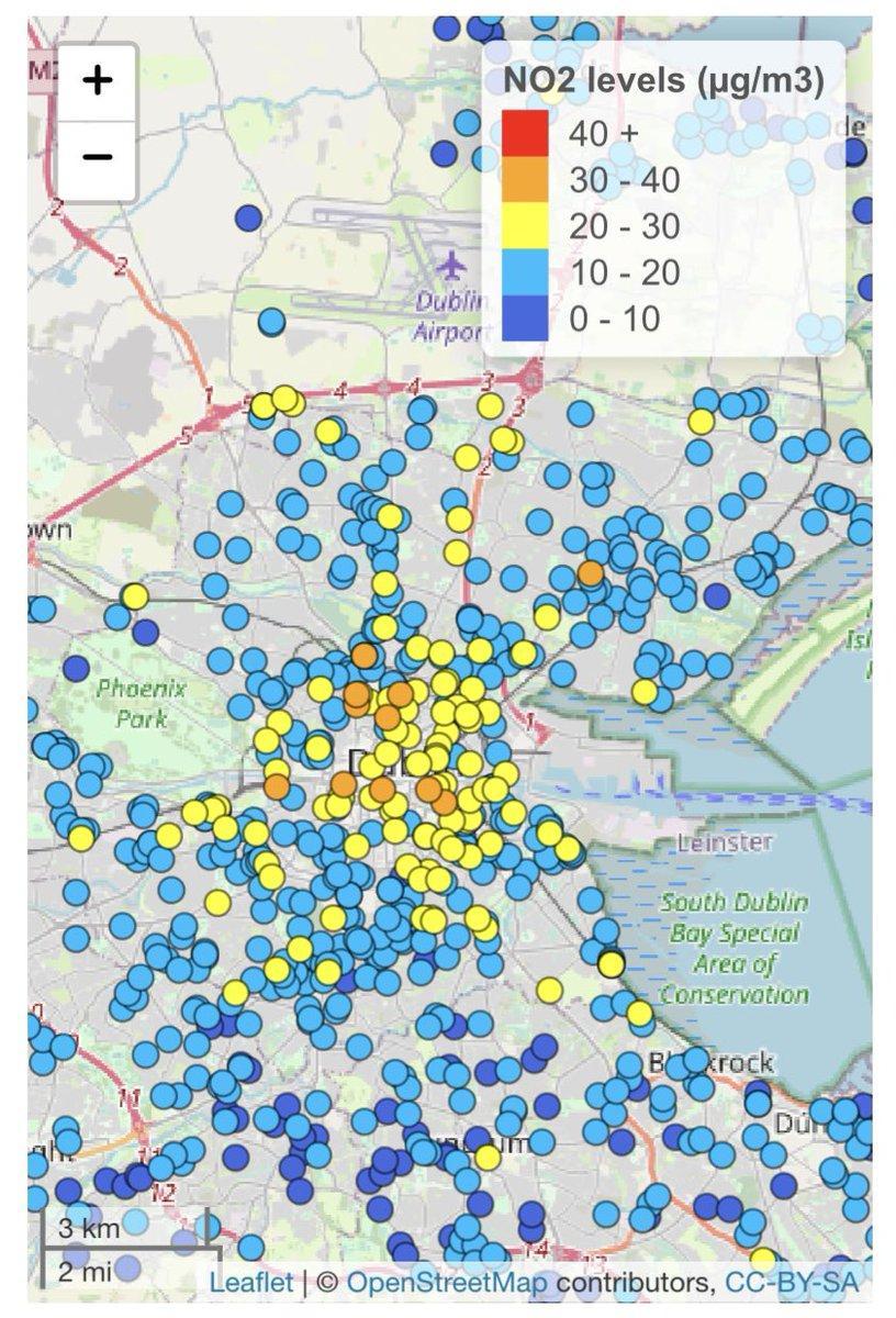
Interestingly, these results were consistent with the Google Project Air View results. Google mapped air quality in Dublin with an electric car going street by street. The results were published in January 2023 and showed that the area within the canals shows really high levels of NO2, with Doyle’s Corner around 55µg/m3, Drumcondra Road between 40 and 55, and the vast majority of the inner city over the WHO’s levels.
The Google results are not included in the EPA’s report – the reason cited being that the Google measurements are done on the road and therefore not admissible.
The government and the EU recently released their clean air strategy, aiming to align the limits within the WHO’s recommendations. This comprises incremental measures, with the aim of being compliant with the WHO’s limits by 2035. One can wonder if the situation is getting the attention it deserves. Very high (and sometimes illegal) concentrations of a harmful pollutant are found everywhere in the city – all major hospitals in the city show dreadful levels of NO2 – St James’, the Mater, Temple St, as well as schools in the inner city, that are three to four times over what the WHO recommends.
Combustion engine exhausts are the main source of NO2. Therefore if you want NO2 levels to come down, you need to curb traffic and reallocate road space for cycling and walking. In Dublin, 60% of traffic is through traffic. In Ireland, 70% of trips are by car, with 50% for less than 5 kilometres. That traffic leaves behind very dangerous pollutants, stunting children’s lungs, and leading to strokes, heart disease and dementia. In Ireland, 1 in 10 children has asthma. Every four minutes, someone in Ireland visits an Emergency Department with asthma.
Switching to electric cars won’t solve the problem — they release Particulate Matter (PM) from tyres and brakes more than ICE cars as they are heavier. PM has been shown to enter the bloodstream and the lungs.
A change in how we view the city and its residents is needed. Every time you talk about traffic in Dublin, the focus is on commuters. 116,000 people live within the canals. Why aren’t we focusing on their health and needs for once?
Anne Bedos is the owner of Rothar which is based on the Phibsborough Road.
And hence why nothing is done epa have no interest as it creates work for them sadly
Thank you Anne. I live in Inchicore, 3 mins walk from Tyrconnell Road, which is bumper to bumper in at least one direction at least 4 hours every weekday. I remember during the lockdown actually being able to smell the canal – rot, dogshit, mulch, it was amazing. I’d love to know if you have figures for the intersection of Tyrconnell Road and Naas Road, or even Tyrconnell Road and Emmet Road? Bus Connects are going to be compounding the problem by removing all the buses currently serving Tyrconnell Road (c. 8 per hour) and replacing them with a single hourly service which appears designed to fail.
Terenure ‘Village’ is as bad as phibsborough I’d say. Surprised they don’t recommend the school kids wear hazmat suits.
Four busy roads all converging in the centre of a town with very few pedestrian crossings is crazy.
I agree that Terenure is extremely hostile for pedestrians and cyclists. To pass through that big junction as a pedestrian, you have to do some logical problem solving in your head to figure out how to cross with no pedestrian lights on 2 roads of the junction (e.g. if they have green light then I can cross in parallel with them, but only to the half way point where I huddle on an island etc). Not only that, but there is one road where the Lidl is that has no dips in footpaths for people with buggies or wheeling. Its just horrendous and so unpleasant. Not sure its much more fun for motorists either. And nobody seems to care…
Which BusConnects scheme are you falling under? If you have not done so already, there is also the Google data that is revealing.
@Anne They’re removing the 68, 69, 13 and replacing them with one bus, 58, once an hour that goes nowhere near the more frequent routes (68 or 13). Not sure what Phase it’s under, but it’s due to come in before the end of the year.
Hi Mia, not a lot of data for your area from Google, but what we have shows levels o Tyrconnell road of between 25 and 40. You can have a look here: https://insights.sustainability.google/labs/airquality?hl=en-US
As for the BusConnects data, it shows a 2029 baseline of around 34µg/m3 for your area. Because this is not over the EU limit there won’t be any clean air plan for the area. But it is still very high and ideally you would have a hyperlocal network for monitoring the situation in real time.
@Anne – thanks a million for this. I’ve sent the link to your article to Sophie Nicoullaud, our local independent councillor who is campaigning with us on the Bus Connects fiasco.